Mt. Mumpu: Climbing Zambia's Tallest Mountain
- Abby
- Jul 14, 2020
- 7 min read

Updated: Sep 15, 2020
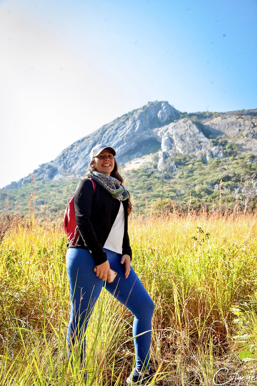
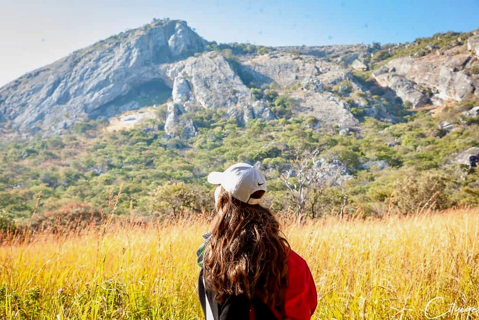
Mt. Mumpu is the tallest free standing mountain in Zambia at 2,000 metres (6,560 feet). It is used for expeditions by Chengelo School and part of Ndubaluba Outdoor Learning Centre, but I have not yet found it to be very widely known around Zambia.

My husband hiked Mumpu in 2005 when he was in high school at Chengelo. I had spoken with him and a number of his friends about the experience and although he didn't love it being a required expedition, and he didn't even recommend it, I decided I wanted to experience it for myself.
A few friends and I had considered hiking it ourselves after speaking with some others who had more recently been, but eventually instead we decided to go with a guide and form a larger group. We ended up forming a group of 20 hikers and 25 total group when including our photographer, guide, chef and helpers. It was a blast meeting other like minded people and adventuring together! I'm really glad we did it this way with a group and guide.

If you are an experienced hiker or very adventurous it is doable on your own, though I would not say it’s as advisable. For peace of mind and a great guided experience, I would recommend Mwaba Mwila who is known for leading trips up Mt. Mumpu numerous times. For more information, Mwaba can be contacted via email at mwilammwaba@gmail.com or on facebook.
We also had an amazing photographer who hiked with us all while constantly capturing the adventures. Thank you to Kino from City Eye Photography! They can be found on instagram and facebook.
Let's get to it!
Recommended time of year to go
Late April to Early May.
This time of year the falls will be higher, the forest will be greener, the temperatures won't be too cold at night and also not too hot during the day.
Despite the fact that we went during the coldest time of the year, I thought our trip worked out well. The nice thing was the hike was very comfortable in the lower temperatures, but the waterfall was pretty cold for swimming and evenings were also quite cold.
Recommended length of time to stay
2 nights minimum - 4 nights maximum
We stayed 3 nights and I think that was the perfect length of time to include the Fort Elwes hike as well as spending time at the falls. We could have added on one extra day for just the falls and camp...but any more than that I can’t imagine what else we would do. If not interested in Fort Elwes hike or want to do it very early in the morning of departure, then 2 nights could be enough. Whether coming from Ndola or Lusaka, it is a long drive in total. For anyone coming from mkushi, or nearby, 1 night might be doable.
Destinations
Mt. Mumpu
Fort Elwes
Chengwena Falls
North Swaka Forest Reserve
Activities
Camping
Hiking
Swimming
Bird watching
Location
Mt. Mumpu is about 35km (around 2 hours) from Mkushi town, in the North Swaka Forest Reserve.
Here are general directions from Mkushi:
Turn right towards the market. Drive through the market which is about 1km.
Continue on through mostly sand dirt road for about 14km. This part is mostly smooth but does have a few rough patches.

After about 14km, on the right hand side there is a sign for a school (no writing from this direction) and this is where you turn. The road will become worse here, it felt like driving on a path through a forest. This rough “road” to get to the campsite is another 21km.

Some parts are grated well whereas many parts have severe dips in the road and require slow speeds and high clearance. My midsize SUV (Nissan Xtrail) did alright but I would recommend using an even higher clearance vehicle.

We were driving in convoy but I got a flat tire...the 4 of us in my vehicle and 2 others in another other vehicle were left behind the rest of the group. We had no cell reception, no maps, no directions and little hope of making it without getting lost. But thankfully, we just tried our best to keep following the road and it landed us right to the campsite.
In total from Mkushi town to the campsite we found that it was a little over 35km.
Campsite
There are no facilities here, it is just a clearing in the forest. We had lots of love that went into our campsite to make the experience much more comfortable, thank you to our amazing team!
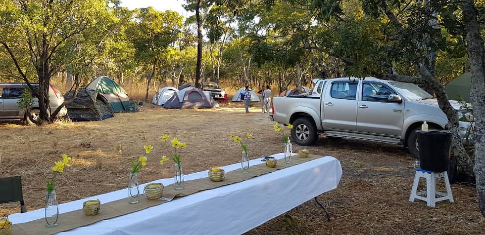
We had a table set up with flowers and candles, though we mostly just ate and sat around the campfire because of the cold temperatures, this was a lovely touch and added a feel of glamping to the experience!

Two bucket showers with heads, coverings and hot water made for a comfortable showering experience. We also had toilet/outhouses that were set up to provide privacy.
Mt. Mumpu Hiking Experience
The walk
We did not begin the day at base camp, so that made for a much longer hike of Mt. Mumpu, almost 14 hours in total! But we were a large group and we took it very slowly. A couple we met there who had never been before and went on their own without a guide, did it in almost half the time. So I would estimate about 10 hours on average.
We started off from camp at 6:15am, crossing a rocky stream and following the same road path for about 8km through the North Swaka Forest reserve. This walk makes the overall experience of climbing Mt. Mumpu much longer of a day. It is possible to drive on this path as it's a similar quality of road as the way to the campsite.
We arrived at the campsite base camp around 8:30am and had breakfast. There is a little more walking until the true base of the mountain, just about 1km. There is no path from there, and really no path or notable way to go for the whole of the hike.

The climb
It starts out as just hill hiking with a rapid ascent. We began around 9am and by 9:30 we already had a high up incredible panoramic view. This first hiking part took us about an hour and was not difficult, but pretty quickly it became steeper until we got to rock climbing and into the cave. Just before the cave, there are steep rocks that require some free rock climbing.

The cave was tricky to manoeuvre but I found it really fun as it was an experience like nothing I had before. Only one person at a time could pass through some of the small crevices so this portion took our group over an hour. This was from about 10-12am.

After the cave, there was more steep climbing with some parts where we had to be strategic about our footing and climbing. This was from about 12-2pm.

After some more tricky rocks, it was just a simple hike up to the summit.

There aren't words to describe this feeling. Looking over Zambia from such a high point was an incredible experience. We ate a late lunch at the top and took photos before quickly beginning our decent. We summited around 3pm.

The way down
Typically, I would imagine the descent would take around an hour or very most two but again we went extra slow from about 3-5:30pm. We went down the other side of the mountain and pretty much just made our own path as we eventually were close to a somewhat hidden waterfall/stream and we followed it to the base.
Our guide Mwaba was very helpful in creating the path and encouraging everyone to finish strong here. The couple who hiked it the next day climbed back down through the bat cave, the same way we climbed up. I thought the way around was an easier decent and nice to experience it from another perspective.

We stopped for some fresh mountain water from the stream to refuel and headed back! The last 8km walk back was about 6-7:45pm. We were walking in the dark so definitely make sure to bring flashlights/headlamps or leave earlier to account for that.
Elevation
Although Mt. Mumpu is the tallest mountain at 2,000 metres above sea level, base camp and most of Zambia is around 1,300 metres. Therefore, the change in elevation is not very intense.
Day Hike Outline Average Estimation
2 hours hike from campsite to basecamp
4 hours hike from base to summit
2 hour hike from summit to base
2 hours hike from basecamp to campsite
Other Destinations
Changwena Falls
The campsite is set right at the top of a beautiful waterfall, just a few minutes walk from our tents. This waterfall has several different drops as well as 3 different pools to swim in. It was difficult to capture such beauty since it goes in stages where you can’t see the top of the falls from the bottom. It is a unique waterfall and despite being some of the coldest days, most of the group still swam and even bathed in there! I can imagine it would be amazing to swim in warmer months.


Fort Elwes
There is a path to Fort Elwes though we took a shortcut along the river for the first part until we reached the path and then continued on there. Again, another reason we were grateful for Mwaba to guide us here.

Since the campsite is located right along the river with Mt. Mumpu and other hills to the right (southeast) we walked along there just through the tall grass and stones without a path. Eventually (about 4km) in, we reached a clearing with a beautiful view of Mt. Mumpu and this is where we met up with the path.

It was amazing to look up to Mt. Mumpu the next day from a new point of view and to think about the experience of hiking it. We continued on the path until we reached some inclined rocky terrain. The path sort of continues up the hill and just a few metres climbing up the rocky hill we found the ruins of an old fort to the left side.

Yes it is just a pile of rocks, but I felt that it was very worth the hike. We had the time and it was nice to keep moving the day after a long hike and take advantage of being there. It is a totally different view of the wilderness. Although there is no signage or history there (or really much known) I loved the experience of being at such a remote historical site. Fort Elwes was built in 1896 by european miners. The fort and mountains are just along the border of Zambia and DRC.


Comments